Demonstration for AI-based Data Set Construction Automation System
페이지 정보

본문
1. Company: Robone
2. Objective:
- To build a realistic maritime image ship data set from various marine environments.
· Build a data set that suits maritime conditions, including various lighting, complex water reflections, and the unique directionality of ships.
· Training through these real-world problems strengthens the model and ensures efficiency in various maritime scenarios.
- Significance of collecting realistic maritime images:
· Provide ship images under various weather conditions and real maritime activities.
· Provide data necessary for accurate distance estimation and attribute prediction by observing ships from various angles and distances.
- Importance of complex and diverse data:
· Various data sets are needed to deal with the unpredictability and complexity of open water.
· The importance of creating a data set that reflects real maritime scenarios is growing.
- Ensuring the reliability of machine learning models:
· Image capture and construction within a research vessel ensure the reliability and efficiency of the model in the actual application environment.
· Ensure accurate ship detection and attribute estimation performance in real operating environments.
3. Key Features:

- Field survey:
· Confirmation of module installation location and completion of installation work.
- Equipment installation and function check of major devices:
· Synchronization of RGB and NIR camera data.
· Synchronization of GPS for camera position.
· Synchronization of camera direction and AIS information of nearby ships.
- Data processing:
· Collected data is processed on land.
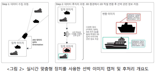
· Connecting AIS data with observed ships through a pre-trained ship detection model.
- Data post-processing:
· Calculation of 3D-2D projection for ships in the image frame.
· Utilization of ship's GPS coordinates (obtained through AIS) and device's position and direction data.
- Obtaining the final result:
· Determining the exact location of ships within the image frame.
· Generating a data set for ship detection that does not rely on radar, AIS, or sonar systems.
- Field cleaning and restoration:
· Module recovery and field cleaning work completed.
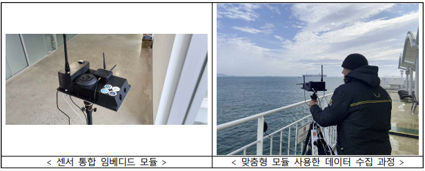
4. Equipment Installed: Sensor integrated embedded module

5. Results:
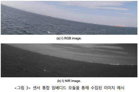
The AISail sensor integrated embedded module is a stand-alone device that can capture RGB/NIR images along with direction and position. With the help of an AIS antenna, it can also extract location information of nearby ships. It is designed with low power consumption (less than 25W), making it suitable for operation using an auxiliary battery or portable battery. To capture images and locations of surrounding ships while avoiding glass reflection, AISail is placed on the upper terrace of the ship, utilizing open space. Data is collected internally, and with this device, there is no need to install it directly on the ship. The images below are examples of images collected through the module.
5-1. Photos of the Test


